
Storms and extreme weather are among the most feared natural events in the United States. In 2025, U.S. meteorologists and climate scientists are tracking shifts in storm patterns, risks of hurricanes, tornadoes, tropical systems, and heavy rainfall. From the Atlantic to the Southwest, recent years have shown how volatile weather can become. In this article, we explore:
- Key recent storms and trends (2024–early 2025)
- The current climate drivers influencing storm activity
- Forecasts and projections for storms in the coming seasons
- Regional vulnerabilities (hurricane coasts, Tornado Alley, desert flash floods)
- How to prepare, adapt, and stay safer
By weaving together science, historical context, and forward-looking insight, this article aims to engage readers interested in weather, climate, safety, and adaptation.
1. Recent & Notable Storms in the U.S.
To understand where we may be headed, it’s useful to look back at some significant storms in recent times.
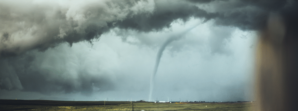
March 2025 Tornado Outbreak (March 13–16)
Between March 13 and 16, 2025, the U.S. experienced a massive tornado outbreak, one of the largest ever recorded in March. A total of 118 tornadoes were confirmed, with some reaching up to EF-4 strength. The event impacted large parts of the Midwest, South, and stretched toward the East Coast. Wikipédia
This outbreak was notable not just for its size but for its timing — occurring earlier in the season than many historic outbreaks — and the breadth of its damage.
Early March Blizzard / Mixed Storm Complex

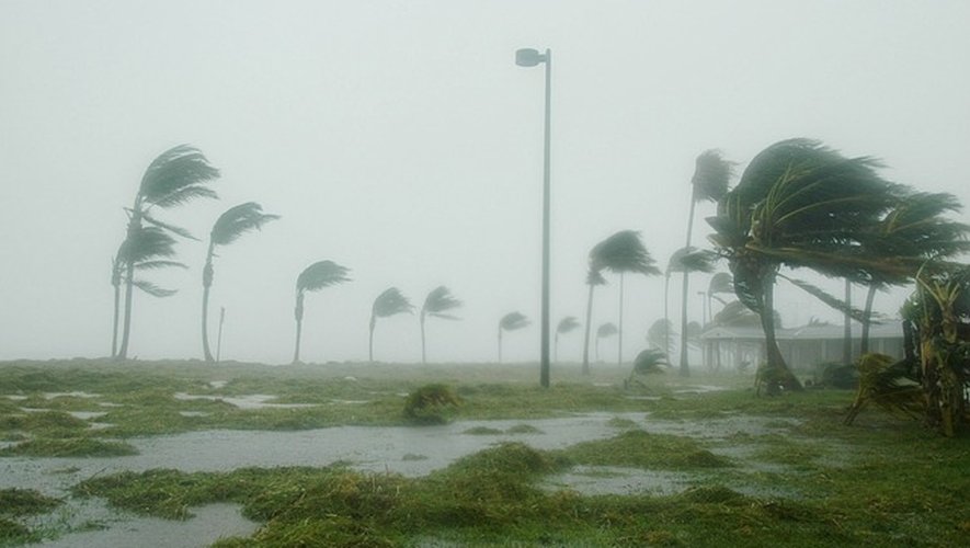
Earlier in 2025, in early March, a powerful extratropical cyclone brought blizzard conditions, heavy snow, strong winds, and even tornadoes to parts of the U.S. Midwest and Southern U.S. The storm created widespread power outages (over 400,000 outages) and was responsible for multiple fatalities. Wikipédia
The strength and complexity of this storm — combining winter snow, wind, and convective storms — illustrates the growing volatility in the U.S. weather system.
February 2025 Storm Complex / Atmospheric River Event
In February 2025, Storm Complexes and atmospheric river events brought heavy rainfall, flash flooding, and tornadoes across parts of California, the Ohio River Valley, and the Southeast. Over 18 deaths were reported. Wikipédia
These events show that storms are no longer as neatly categorized by season or geography; systems are increasingly overlapping and producing multi-hazard impacts.
2. Climate & Weather Drivers Influencing Storms in 2025
Storm risk and behavior aren’t random — they are modulated by large weather and climate systems. Understanding these helps us anticipate what’s ahead.
La Niña / ENSO Effects
Currently, La Niña conditions are observed in the Pacific. A La Niña phase tends to bring a cooler central/eastern Pacific, which often influences U.S. weather by shifting jet streams and altering moisture flows. Midland Daily News+1
In U.S. winters and springs, La Niña years can enhance conditions for severe storms in some regions and influence tropical cyclone formation or paths in Atlantic basins.
Sea Surface Temperatures & Ocean Warming
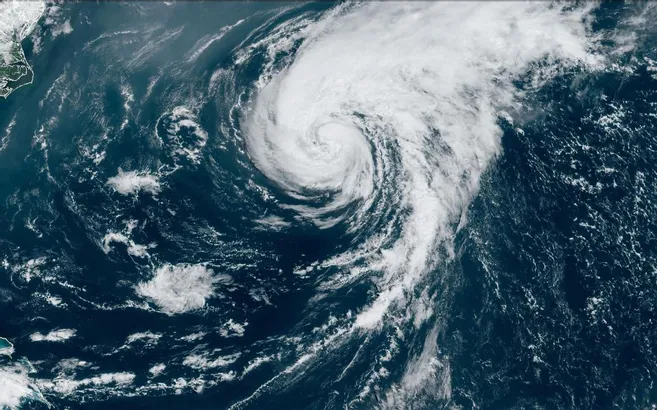
Warmer ocean waters fuel tropical storms and hurricanes by providing more latent heat (the energy storms need). In 2025, Atlantic sea surface temperatures are above average, which contributes to a forecast of an above-normal hurricane season. Reuters+2Wikipédia+2
However, other factors such as wind shear, atmospheric stability, and steering currents (jet streams, high/low pressure systems) will still play critical regulatory roles.
Atmospheric Instability & Convective Parameters
Storm strength is driven by local instability (CAPE — Convective Available Potential Energy), wind shear, moisture, and triggers (fronts, dry lines). Some studies show that environments favorable for extreme thunderstorms are increasing in U.S. regions during spring and summer months. arXiv
This means more days when storms can become severe (hail, damaging winds, tornadoes), particularly in traditional severe weather zones.
Jet Stream Patterns & Synoptic Systems
The position of the jet stream, upper-level troughs and ridges, and synoptic scale disturbances set the stage for major storm development. More wavy jet streams or blocking patterns can stall storms, intensify them, or plunge cold air further south.
As climate change shifts baseline temperatures, the dynamics of these large-scale patterns may change too, affecting how and where storms form.
3. Forecasts & Projections: What Storms May Come
While weather forecasting deals with days to weeks, climatological forecasting looks at seasonal and multi-year trends. We combine both to see what storms the U.S. might expect in 2025 and beyond.
Hurricane / Tropical Storm Outlook
The 2025 Atlantic hurricane season is forecast to be above average. NOAA, Colorado State University (CSU), and other entities expect 13–19 named storms, 6–10 hurricanes, and 3–5 major hurricanes (Category 3 or higher). Reuters+1
Key drivers: elevated sea surface temperatures, favorable ocean heat content, and possibly weakening of inhibiting wind shear fields.
In the Pacific region, forecasts for 2025 suggest 12–18 named storms, with 5–10 potentially reaching hurricane strength. Wikipédia
Thus, both Atlantic and Pacific basins could see elevated tropical activity.
Regional Storm Risks & Seasonal Highlights
- Gulf & Atlantic Coasts: Higher chance of landfalling hurricanes or tropical storms, storm surge risk, heavy rainfall flooding, especially in low-lying or coastal zones.
- Tornado Alley / Midwest / Southeast: Elevated spring and early summer risk of severe thunderstorms and tornado outbreaks, especially in March–May windows.
- Southwest & Desert States: Flash flooding risk from monsoonal moisture or remnants of tropical storms migrating inland. Also, strong thunderstorm activity in isolated settings.
- Northern States / Upper Midwest / New England: Early and late season winter storms, nor’easters, strong extratropical cyclones, snow + wind combination hazards.
Possible Storm Scenarios in 2025
Here are plausible storm scenarios to watch:
- major hurricane making U.S. landfall in the Gulf or Southeast, causing flooding, wind damage, and storm surge.
- large tornado outbreak in spring in the central U.S., stretching into the Southeast or Ohio Valley.
- A combined winter-to-spring system bringing blizzard, freezing rain, wind, and secondary severe convection.
- Flash floods in arid regions (Arizona, New Mexico) due to atmospheric rivers or tropical moisture influx.
- Coastal nor’easters in the Northeast with heavy rain, coastal flooding, damaging winds.
4. Regional Vulnerabilities & Risk Hotspots
Storm risk is not evenly distributed — some regions face unique vulnerabilities.
Gulf & Atlantic Coastal Zones
- Elevated storm surge, flooding, and hurricane landfall risk.
- Many communities are low-lying, with drainage and infrastructure challenges.
- Coastal erosion, saltwater intrusion, and insurance exposure increase resilience pressures.
Tornado Alley & Tornado-prone Regions
- States like Oklahoma, Texas, Kansas, Nebraska, Arkansas, Mississippi, Louisiana face recurrent tornado risk.
- The March 2025 outbreak shows that large outbreaks can happen earlier and be extremely damaging. Wikipédia
Desert & Arid Regions (Southwest)
- Flash floods are a major hazard: rainfall over dry ground can’t drain quickly.
- Terrain, canyons, and burn scars from wildfires amplify runoff and flood risk.
Northern & Mountain States
- Winter storms, blizzards, ice, and rapid transition events (snow to rain).
- Mountain terrain increases complexity: avalanches, altitude wind, rapid temperature swings.
Urban & Infrastructure Risks
- Cities with dense populations and aging infrastructure are particularly vulnerable to power outages, downed trees, drainage failures, and emergency response challenges.
- Transportation corridors (interstates, bridges, tunnels) may be impacted by wind, flooding, or debris.
5. Preparation, Adaptation & Safety Measures
Forecasts matter only if people act. Here are practical steps and strategies that individuals, communities, and policymakers should adopt.
For Individuals & Households
- Stay informed: use National Weather Service alerts, local forecasts, severe weather apps.
- Prepare an emergency kit: water, non-perishable food, flashlight, batteries, first aid, backup power.
- Secure property: tie down or remove loose outdoor objects, inspect roofing and drainage, maintain trees.
- Know flood zones and evacuation routes if you live in coastal or flood-prone areas.
- In tornado-prone areas, have a safe room or shelter plan (basement or interior strong room).
- Monitor updates during storms; obey warnings and evacuation orders.
For Communities & Local Governments
- Invest in resilient infrastructure: better drains, flood barriers, coastal protection, stronger building codes.
- Enhance early warning systems and public communication systems.
- Design and maintain storm shelters and safe zones.
- Land-use planning that discourages development in high-risk zones.
- Train emergency services, coordinate multi-jurisdictional storm response plans.
For Policy & Climate Planning
- Incorporate climate change projections into storm-risk models.
- Invest in coastal buffer zones (wetlands, dunes) to reduce storm surge impact.
- Support funding for updating electrical grids, drainage, and stormwater systems.
- Encourage nature-based solutions: green infrastructure, retention basins, permeable surfaces.
- Strengthen coordination between federal agencies (like NOAA, FEMA) and states/local governments.